Water Level and Telemetry
River and jetty water level monitoring: sensors, telemetry and alarms
An AWLR measures water level automatically and sends it by telemetry. This guide covers sensor choice, mounting, remote power and alarms for rivers and jetties.
- Topic
- Water Level and Telemetry
- Updated
- 13 November 2026
- Reading time
- 6 min
- Sections
- 7
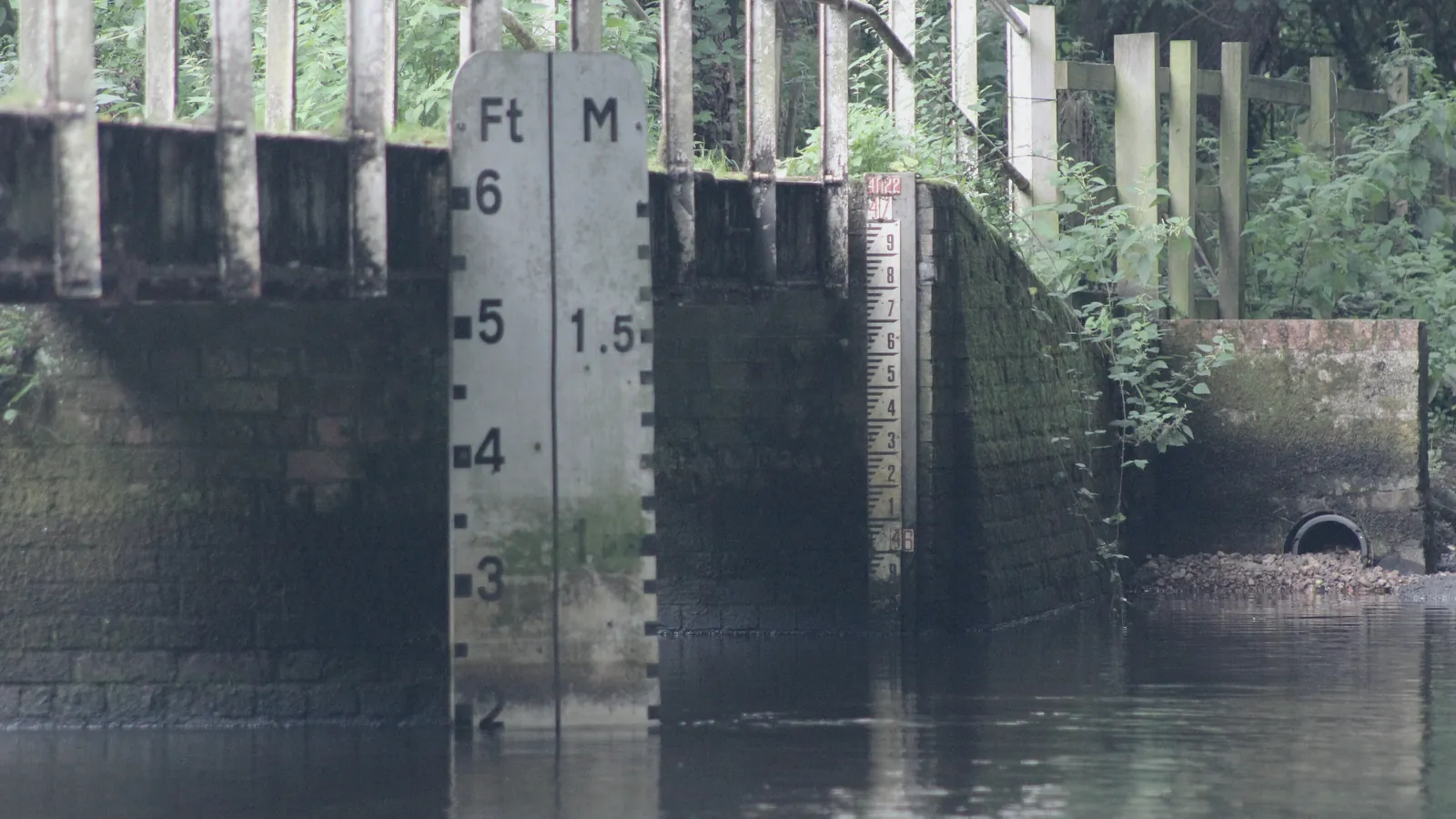
AWLR (Automatic Water Level Recorder) is a station that measures and records the height of a water surface automatically, usually with a radar or pressure sensor, and sends the data through telemetry to a dashboard.
The same idea serves hydrology and operations. A water agency uses it to follow rivers and floods. A mine or port uses it to decide when a barge can approach a jetty. This guide covers the parts of a station, how to choose between radar, ultrasonic and pressure sensors, why mounting decides accuracy, how remote stations are powered and connected, and how to set alarms that match a real decision.
Station
What an AWLR station contains
A station is a sensor, a data logger, a modem and a power supply in one weatherproof enclosure, mounted over or beside the water.
The sensor measures a distance or a pressure. The logger turns that into a level against a known reference, called the datum, stores it and sends it at set intervals. The modem carries it to a server over a cellular or radio link. The enclosure also holds surge protection and grounding, because a station on an exposed riverbank is a natural target for lightning.
Level is only meaningful against a datum, so someone must survey the sensor height to a benchmark and check the reading against a staff gauge. The WMO Guide to Hydrological Practices (WMO-No. 168) covers networks, instruments and observation methods for hydrological stations, and is the general reference behind this kind of work.
Radar, ultrasonic or pressure sensor reading the water surface.
Hover, focus or tap a step to read its note.Sensors
Radar, ultrasonic or pressure sensor?
Radar, ultrasonic and pressure sensors all give water level, but they meet the water in different ways. Radar and ultrasonic sensors look down from above and never touch the water. A pressure sensor sits under the surface and measures the weight of the water above it.
Radar suits rivers because the reading is little affected by air temperature, humidity or rain, and the sensor stays out of floating debris and flood flow. Ultrasonic sound speed changes with air temperature, so the sensor needs temperature compensation and is more affected by wind and by vapour over the water. Pressure sensors suit sites where nothing can be mounted above the water, but they sit in silt and debris, drift as they foul and need correction for atmospheric pressure unless they are vented.
A vendor datasheet shows what the radar class offers. VEGA lists the VEGAPULS C 21 with a 20 m measuring range, ±2 mm accuracy and an 80 GHz frequency, and names water treatment, pumping stations and rain overflow basins as typical uses. Its outputs include 4-20 mA with HART, Modbus and SDI-12, a serial protocol common on hydrological loggers. Output basics are in the 4-20 mA and HART guide.
| Criterion | Radar | Ultrasonic | Pressure (submerged) |
|---|---|---|---|
| Contact with water | None | None | Under the surface |
| Air temperature effect | Little | Needs compensation | None, but needs air pressure correction |
| Debris and flood flow | Sensor stays clear of the flow | Sensor stays clear of the flow | Sits in silt and debris, may foul |
| Mounting | Bracket or structure over the water | Bracket or structure over the water | Cable to a fixed point in the water |
| Common weak point | False echoes from nearby structures | Wind, vapour and temperature | Fouling, drift and cable damage |
- Example sensor
- VEGAPULS C 21, wired radar sensor
- Measuring range
- 20 m
- Accuracy
- ±2 mm
- Frequency and beam angle
- 80 GHz, 8°
- Ambient temperature
- -40 to 80 °C
- Protection
- IP66/IP68
- Outputs
- 4-20 mA/HART, Modbus, SDI-12
Installation
Mounting decides the accuracy
A radar sensor reads the surface well only if its beam sees the surface and nothing else. Most bad readings trace back to where the sensor was mounted.
Citia’s river water level monitoring project for PT Adaro Energy in Barito Selatan, Kalimantan Tengah, shows the pattern. The site was remote, the weather changed often and there was no grid power. The VEGAPULS C30 radar sensor needed a carefully chosen mounting position so that the surface, nearby structures and other site conditions did not disturb the reading. The team ran a full field survey first, then installed, calibrated and verified the sensor and tested communication before commissioning.
Keep the beam clear of piers, banks and the bracket itself, which return false echoes. Mount the sensor above the highest level you expect, point it straight down at the water and compare readings with a staff gauge at more than one level.
Survey the site and the datum
Check access, structures, flood marks and a benchmark to reference.
Choose the mounting point
Clear of structures and above the highest expected level.
Mount, align and configure
Point the sensor straight down and set the measuring parameters.
Calibrate and verify
Compare with a staff gauge at several levels.
Test power and communication
Confirm the battery, solar charging and the data link.
Commission and document
Record the datum, settings and test results.
Remote sites
Power and telemetry for remote stations
A river station often sits where there is no grid power and the mobile signal is weak, so power and communications are designed before the sensor is chosen.
Size the solar panel and battery for the worst weeks of the rainy season, not for an average day. Reading interval is a trade-off: shorter intervals cost energy and data. A common design reports at a slow routine interval and switches to a faster one when the level passes a set threshold. Keep a local log in the data logger so that readings survive a lost link and fill in when it returns.
Plan visits around the rainy season. Before it starts, clean the radar lens, check the solar panel for shading from new growth, test the battery under load and read the staff gauge against the sensor. After a flood, check the mounting for movement, because a bracket nudged by debris changes the reading without any alarm.
Choose the link from a coverage test at the pole. Cellular is simplest where there is a signal, and radio or satellite fills the gaps. The station must report its own health: battery voltage, signal strength and the time of the last message. Citia describes this class of system on its CATALYST Telemetering page, and the industrial IoT gateway guide covers the data path.
Solar and battery
Sized for the worst weeks, with voltage reported.
Cellular or radio link
Chosen from a coverage test at the pole.
Local logging
Readings kept when the link drops.
Surge protection
Grounding and arrestors for lightning-prone sites.
Alarms
Alarm thresholds that mean something
An alarm is useful only if it matches a decision. Define each level by the action it triggers, and the thresholds follow from the site.
For a jetty, the limits come from the draught the vessels need and the structural limits of the berth. For a flood point, they come from the level where the bank, road or plant area goes under water. Alarm on rate of rise as well as absolute level, because a river that climbs fast leaves less time than one that is high but steady. Alarm on a flat line or missing data too, because a stuck sensor looks like a calm river.
Send alarms to the people who can act, by the channel they actually read, and test the whole chain with a simulated level before the rainy season.
- Normal
- Level within the usual operating range
- Watch
- Level approaching a site-defined limit; inform the duty supervisor
- Warning
- Limit crossed; hold or reschedule vessel movements
- Critical
- Safety limit crossed; follow the site emergency procedure
- Rate of rise
- Change per hour above the site value, at any level
- Sensor and station fault
- No data, flat line, out-of-range value, low battery or lost link
Data quality
Checking the data before you trust it
A line on a dashboard is not a measurement until someone has checked it. Automatic checks catch most faults before an operator sees them.
Four checks cover most cases. A range check rejects values outside what the sensor and the site can physically produce. A rate check flags jumps that no river makes in one interval, which usually means a false echo or a bird on the bracket. A flat-line check catches a frozen sensor. A comparison with the staff gauge, read on every visit, catches slow drift in the datum or the sensor height. Mark suspect values instead of deleting them, so the record keeps its history and a later review can decide.
Level is not flow. Hydrologists convert level to discharge with a rating curve built from field gaugings, and the curve changes as the riverbed changes. The WMO Manual on Stream Gauging (WMO-No. 1044) covers the fieldwork and the computation. A jetty operator usually needs only the level, but a flood or water-resource study needs the curve as well.
Operations
Why level matters for jetties and logistics
On a river or coast, water level decides when a vessel can move. It also decides when the berth is safe to work.
Citia’s technical bulletin on water level monitoring for jetty safety and vessel berthing explains the risk. Tides, extreme rain or changes in river flow can endanger vessels, the jetty and workers, and loading and unloading of materials such as oil and gas, coal and cargo are sensitive to water conditions. Level sensors with critical-threshold alarms, a web dashboard and SCADA integration let operators decide quickly and schedule loading with more precision.
The Adaro Logistics Tuhup Jetty note describes cloud-based river level monitoring that supports logistics management at the jetty, and the water level telemetering note lists web and mobile access to the data and alerts for sudden changes. For a barge operator, the benefit is simple: fewer moves attempted in water that is too low or rising too fast.
Terms used in this article
- AWLR
- Automatic Water Level Recorder, a station that measures and records water level automatically.
- Datum
- The fixed reference height that water level is measured against.
- Staff gauge
- A graduated board in the water used to read level by eye and check the sensor.
- Telemetry
- Sending measurements from a remote site to a central system.
- Data logger
- A device that stores readings and sends them on a schedule.
- SDI-12
- A serial protocol used by many environmental and hydrological sensors and loggers.
- Rate of rise
- How fast the water level changes over time, for example per hour.
- Draught
- The depth of a vessel below the waterline, which sets the water depth it needs.
Frequently asked questions
What is an AWLR?
An AWLR, or Automatic Water Level Recorder, is a station that measures and records water level automatically and usually sends the data by telemetry. It combines a level sensor, a data logger, a communication link and a power supply.
Which sensor suits a fast river?
A radar sensor is usually the best fit, because it measures from above and stays out of the flow, debris and silt. Mount it above the highest expected level with a clear beam to the water.
How does a station run without grid power?
It runs on a solar panel and battery sized for the worst weeks of the year. Low-power loggers, a controlled reporting interval and battery alarms keep it running between visits.
Why does water level matter for barge jetty operations?
Level decides whether a vessel can berth and load safely. Tides, heavy rain and changes in river flow can endanger vessels, the jetty and workers, and level alarms give operators time to react.
How do I check that a radar level reading is correct?
Compare it with a staff gauge at several levels. A consistent offset points to a datum or height error, while readings that jump point to false echoes from structures in the beam.
Can water level data go into SCADA?
Yes. A station or its server can pass level and alarms to SCADA over a standard protocol such as Modbus, so operators see river level next to the rest of the plant.
Sources and further reading
- Hydrology Publications (Guide to Hydrological Practices, WMO-No. 168; Manual on Stream Gauging, WMO-No. 1044) (opens in a new tab)
- VEGAPULS C 21 (opens in a new tab)
- Adaro: water level monitoring system (opens in a new tab)
- Water level monitoring for jetty safety and vessel berthing (opens in a new tab)
- Adaro Logistics: Tuhup Jetty (opens in a new tab)
- CATALYST Telemetering (opens in a new tab)
- Cover photo by Martinvl, CC BY-SA 4.0 (cropped and colour graded) (opens in a new tab)
Next step
Prepare the technical discussion for your facility.
Bring the equipment list, diagrams and symptoms you have. The Citia team helps map the next step.
Related products and solutions
- Knowledge4-20 mA and HART: how field instruments send dataA 4-20 mA loop sends a measurement as current; HART adds digital data on the same wires. How the loop works, how to convert mA to a value, and how to read faults.
- KnowledgeWhat is SCADA? Components, architecture and industrial examplesSCADA collects data from PLCs, RTUs and instruments, shows it to operators and sends supervisory commands. Components, architecture and real plant examples.
- ProjectAdaro: water level monitoring systemCitia installed a VEGAPULS C30 radar river water level monitoring system with solar power at the PT Adaro Energy operational area in Barito Selatan in 2022.
- NewsAdaro Logistics: Tuhup JettyA reference for cloud-based river level monitoring for logistics management at Tuhup Jetty.
- NewsWater level monitoring for jetty safety and vessel berthingCovers water level sensors, critical-threshold alarms and web dashboards connected to SCADA for jetty and vessel berthing operations.
- NewsWater Level Telemetering SystemDescribes sensor-based water level data collection, level-change alerts and data access through web and mobile platforms.
- ProductCATALYST TelemeteringBrings level, pressure and panel readings from remote sites to one dashboard.
- KnowledgeIndustrial IoT gateways and telemetry: getting remote-site data to a dashboardAn industrial IoT gateway reads field devices, buffers data when the network drops and sends it to a server. How telemetry differs from SCADA and how to choose a gateway.